While doing literature research for potential rockhounding locations, I discovered several abandoned copper mines in the western North Carolina mountains. One of these locations was described in a 1940's USGS publication that included a detailed description of the rocks and a site map of the old workings. According to the publication, the mine was last worked for a brief time in the 1930's. Although the mine was not named on any topographic or geologic map in my possession, I was able to pinpoint its location by matching the descriptions and site map with certain features on a more current USGS topographic map. So, armed with the mine's GPS coordinates, I set out to see if I could actually find it in the field.
 On certain days when Chrissy spends the day visiting her parents, I will choose to attack trails that she would find less than enjoyable to climb.
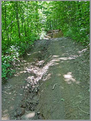
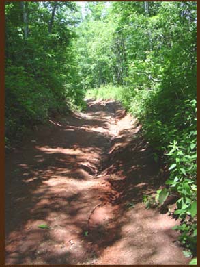 As is typical in many rugged backwoods areas of western North Carolina, I found that the old forest road that I had to drive to the copper mine was badly rutted, rocky, pitted and very steep in spots. I probably should have been driving on a 4X4 recreational vehicle instead of my Dodge 4X4 pickup, but you gotta do what you gotta do when you're chasing rocks - besides, there wasn't exactly anywhere to turn around on the extremely narrow road. I somehow managed to reach a gap where the road leveled out and came to a "T". I got out and inspected the road on the opposite downward side of the gap. It was obviously far too rutted and slick for my truck to handle, so I decided to park and hike from there.
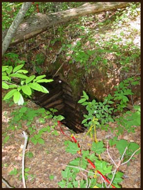
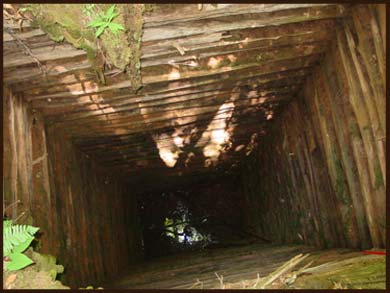
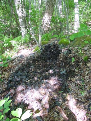
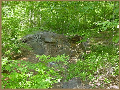
Using mostly my GPS unit for direction, I hiked on the road and bushwhacked through a thick forest for a total of about 1/2-mile until I came upon an old shaft. This must have been one of two shafts described in the USGS publication. I got as close to the edge as I dared to peer down into the darkness. A series of tunnels were reportedly driven at near right angles to the main shaft at various levels, although a fear of falling to my death preventing me from searching for their openings. I continued walking and came upon a second shaft. This one, pictured below, had reportedly been abandoned during the mining operations after having been constructed to a depth of approximately 30 feet below grade. The side timbers were in remarkably good shape considering that they had been installed at least 70 years ago.
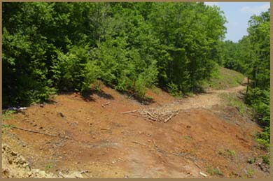
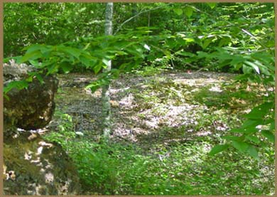
I emerged from the woods onto an open dirt and rock strewn area that must be the heart of the mine's main spoil piles. No plants could grow where an abundance of sulfides from the copper ore had been strewn decades earlier. As sulfides oxidize, decay and mix with water, sulfuric acid is produced which is toxic to most plants. However, there existed only a relatively small denuded area and many more less sulfidic rocks could be found scattered throughout the forest in a down slope direction.
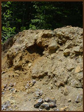
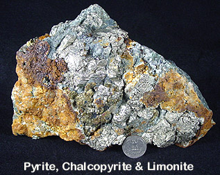
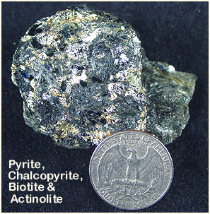
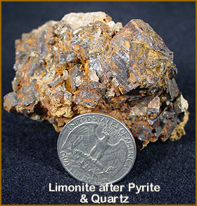
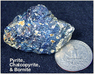
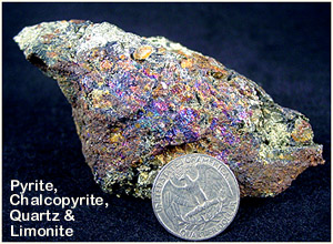
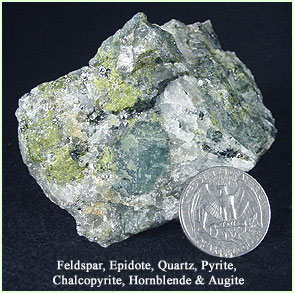
Scattered amidst the spoil piles were rocks made up of a wide variety of minerals, including pyrite, chalcopyrite, quartz, pyrrhotite, feldspar, epidote, hornblende, augite, quartz, bornite, limonite after pyrite, biotite and actinolite.
| |
| |
The tarnished surfaces on some of the rocks were exemplified by peacock colored iridescence.
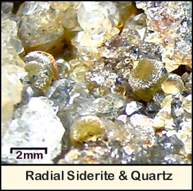
I found some small pockets in some of the quartz-rich boulders that contained micro quartz crystals and what I, with help from my friends on the McRocks' message board, determined to be radial siderite.
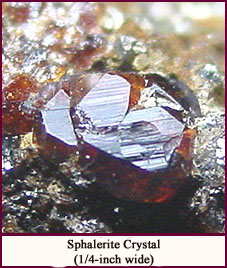
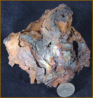
After collecting a heavy pile of rocks at the main spoil pile, I followed the site map down to an area where a smelter operation was shown to have existed. On my way, I came upon a boulder that appeared different from what I had seen earlier. Upon busting it up, I found that the rock contained quartz, epidote, biotite, hornblende, augite, chalcopyrite and greenish-blue plagioclase var. feldspar. I surmise that some of the feldspar has been stained by the oxidation of the abundant copper sulfides. Much to my surprise, there was also a small gemmy sphalerite in the mix. I started to notice that many of the other rocks in the area contained what I first thought was garnet, but turned out to be massive to crystalline sphalerite along with magnetite, galena, quartz and what appears to translucent to clear crystalline fluorite. What a mixed bag of minerals for such a small area!
| |
The map of the former smelter area was very accurate. I found a relatively flat area near a creek where the smelter and its foundation had once stood.
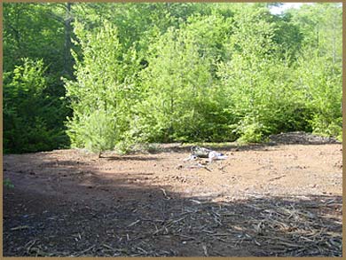
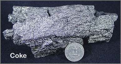
Hidden in the woods were piles of coke, slag and ore.
| |
|
Slag was scattered over a wide area from its pile to the creek. As if my pack wasn't already heavy enough, I couldn't resist collecting some of it as I thought the man-made rock was actually quite beautiful. I also collected a few pieces of coke having never seen it before, but lucky for me it is as light a pumice being composed of highly porous carbon.
| |
For those of you who don't know (like me before I looked it up on the NET), coke is a solid carbonaceous material derived from destructive distillation of low-ash, low-sulfur bituminous coal. The volatile constituents of the coal, including water, coal-gas and coal-tar, are driven off by baking in an airless oven at temperatures as high as 1,000 degrees Celsius so that the fixed carbon and residual ash are fused together. Coke (carbon) is used a fuel in the smelting process to separate a metal (in this case copper) from its ore. Slag is, more or less, the vitrified by-product that is separated from the ore during smelting
Hiking back to my truck was made far more difficult due to a heavy pack full of rocks and steep incline. But, I made it alright and managed to negotiate the treacherous road back down the mountain before making my way home.
CLICK THE LITTLE MINER TO RETURN TO THE FIELD TRIP PAGE
