Winter of 2006 2007 hung on a little later this year, and an early March snowstorm that dumped over 40 inches on the Marquette area put our spring UP trip in serious doubt. I had been in email contact with a new buddy, Jeff Copperrock Rank of Lake Linden in the Keweenaw who assured me that the region should be mostly snow free by the time we got there, and thankfully he was right. Still, we needed to be prepared for cold nights.
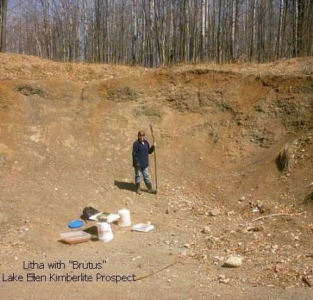
Plans for this trip included building a sifting screen to use at our first rock hunting location, the Lake Ellen Kimberlite Prospect in search of Pyrope Garnets ; possibly Corundum and even Diamonds (though I probably wouldnt know a Diamond if I saw one). As the day to leave approached we were ready, to return to one of Gods special places, Michigans Upper Peninsula.
Thursday April 26th
We left the house at 9:05 in light rain. It rained most of the way through the lower peninsula. We stopped in Gaylord for lunch, then moved on to the Mackinaw Bridge and the UP. On US2 there was a sign for a garage sale, so we stopped. I found a couple items for resale, then we continued down US2 to Manistique where we stopped at Traders Point Antiques. They had lots of nice high priced items there, but nothing I could make any money on, so we were off again; through Escanaba, up through Felch, and finally to Genes Pond, where, once again as the only campers in the park, we would spend the night. At Genes Pond, we walked down to the boat launch area to get a better view of this good sized lake. It was a cool night, but Litha and I were warm enough in the van.
Friday April 27th
 Before sunrise we heard loons on the lake; one of the unique characteristics of this park. We ate a quick breakfast and headed out for Lake Ellen. On our
way out of the park, we saw three fawns in the woods near the road. We took the connecting road west to 95, up to Channing, and northwest to the Lake Ellen area. The digging site is between Lake Ellen and the Michigamme Reservoir, actually closer to the big reservoir. The road to the digging area has a sign that says Public Recreation Area #14 or 41, something like that. The road entering the woods had a couple of deep mud holes, so we parked the van and walked to the digging site, noticing large rock outcrops on the northeast side
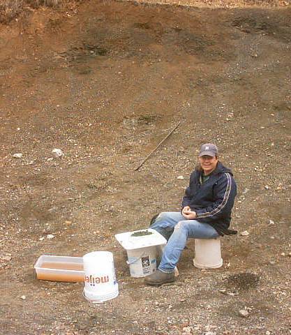
of the two track logging road. Seeing it was drivable, we retrieved the van, and on our way back to the Kimberlite I stopped at an area of standing water to fill up a 5 gallon bucket for sifting. There is a perfect spot for about one vehicle to park right next to the pit. When we got there it was a cloudy cool
Before sunrise we heard loons on the lake; one of the unique characteristics of this park. We ate a quick breakfast and headed out for Lake Ellen. On our
way out of the park, we saw three fawns in the woods near the road. We took the connecting road west to 95, up to Channing, and northwest to the Lake Ellen area. The digging site is between Lake Ellen and the Michigamme Reservoir, actually closer to the big reservoir. The road to the digging area has a sign that says Public Recreation Area #14 or 41, something like that. The road entering the woods had a couple of deep mud holes, so we parked the van and walked to the digging site, noticing large rock outcrops on the northeast side
of the two track logging road. Seeing it was drivable, we retrieved the van, and on our way back to the Kimberlite I stopped at an area of standing water to fill up a 5 gallon bucket for sifting. There is a perfect spot for about one vehicle to park right next to the pit. When we got there it was a cloudy cool
 morning, but not long into our dig blue sky parted the clouds and it warmed up
nicely. We dug and sifted through the morning, ate lunch in the van, and returned to the pit to sift for a few more hours. I checked in several different areas in the wall of the pit, but one spot closer to the floor of the pit seemed more productive. We found quite a few small Pyrope Garnets, the largest (so far) being about ½ inch. Before leaving I filled up a 5 gallon bucket with gravel from my honey spot to sift later and share with friends.
morning, but not long into our dig blue sky parted the clouds and it warmed up
nicely. We dug and sifted through the morning, ate lunch in the van, and returned to the pit to sift for a few more hours. I checked in several different areas in the wall of the pit, but one spot closer to the floor of the pit seemed more productive. We found quite a few small Pyrope Garnets, the largest (so far) being about ½ inch. Before leaving I filled up a 5 gallon bucket with gravel from my honey spot to sift later and share with friends.

We finished up by 4:00 and drove to Van Riper State Park near Champion for the night. The first snow we saw on the whole trip was a small pile in a parking lot at Van Riper. It turned out to be another cold night.
Saturday April 28th
In the morning we spent some time looking for yard sales in Negaunee, then drove to the Cliffs Shaft museum and confirmed that the field trip was still on
 for the following Saturday. After that we left for the Keweenaw. There was still lots of ice floating in the Keweenaw Bay. In Chassell we made a couple of stops to buy antiques, and then we moved on to Houghton for lunch. We were hoping to catch the Seaman museum open, but no luck on a Saturday. Then we went south to our next prospective prospecting place, the Champion #3 mine in Painesdale. When we arrived, there was a closed gate with a sign saying, Property of the Houghton County Road Commission. Its interesting how plans change according to the location. Luckily the Keweenaw has plenty of back up
mines to hunt at. We continued south, searching unsuccessfully for the road to the Globe mine. With plenty of day left, we decided to scout one of our
for the following Saturday. After that we left for the Keweenaw. There was still lots of ice floating in the Keweenaw Bay. In Chassell we made a couple of stops to buy antiques, and then we moved on to Houghton for lunch. We were hoping to catch the Seaman museum open, but no luck on a Saturday. Then we went south to our next prospective prospecting place, the Champion #3 mine in Painesdale. When we arrived, there was a closed gate with a sign saying, Property of the Houghton County Road Commission. Its interesting how plans change according to the location. Luckily the Keweenaw has plenty of back up
mines to hunt at. We continued south, searching unsuccessfully for the road to the Globe mine. With plenty of day left, we decided to scout one of our
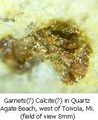
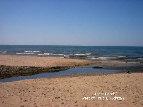
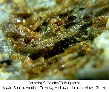 stops for the next day, Agate Beach, west of Toivola. The drive down Misery Bay Road is a nice one, and at one long downward slope you can see Lake Superior in the distance well before you get to the beach. As we got to the small park at the beach, we could see by the whitecaps that the wind and waves were up. I thought about putting on the hip boots but decided to save that for the next day. On our walk I found a quartz beach rock with what I think is garnet.
Litha noticed a Bald Eagle soaring high above the beach in search of dinner. The afternoon was getting towards evening, and we left to find our camp for the night, Emily Lake State Forest Campground. The temps were warmer here, and the mosquitoes were out in droves. The cold I had caught a couple of days earlier was hitting me harder now, and we spent the duration of the evening resting up for the next day.
Sunday April 29th
After breakfast we tried to locate the site of the Indiana mine, but when we finally found it we were greeted by another closed gate and private property signs. Too bad. Next we made our way towards Agate Beach. On the way I stopped
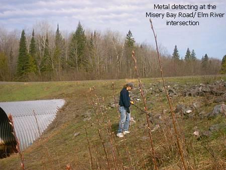 at a couple areas where mine rock was used next to the road. One of these spots was on Misery Bay Road where the Elm River crosses. I found several pieces of mine rock (mostly basalt) that had veins of copper, but nothing real special.
By the time we got to the beach, the wind and waves were even stronger than the day before. With hip boots on, we were still restricted to the first few feet of water. Litha saw her Eagle once again soaring overhead. I hope he had more luck finding lunch than we did finding agates. Even though we scoured the beach, Agate Beach didnt live up to its name. I dont believe we found a single one that day. I panned at a few different areas of black sand but found no sign of gold.
At about mid afternoon we headed back north towards Houghton, but first we did manage to find the road that leads to the old overgrown Globe mine area. This overgrown two track is blocked by mine rock, so we parked near the pile and put on our hiking boots. The hilly terrain and my cold took its toll, and since we didnt see any likely places to prospect, we turned back. On the way out I noticed the tell tale water filled pit with raised areas that had been dug recently, but we were about beat, so I made a mental note to go back there on a future trip. We returned to the van and drove to Houghton, crossed the lift bridge over Portage Canal and went to Calumet to stock up on supplies. At last we drove to McLain State Park and registered for the next few days, learning that we were the only campers in the park. This park is a popular place to walk and rollerblade, so we werent exactly alone. The wind off Lake Superior was cold and we got ready for a chilly night.
Monday April 30th
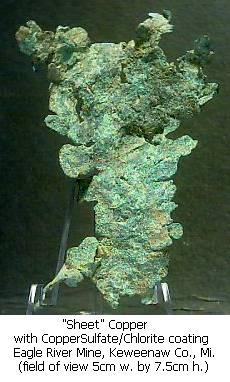 We awoke to a cold morning, ate a quick breakfast, and went in search of the Central mine. My memory of the entrance was a bit foggy, and I thought we had driven too far north, so we turned around, and I found a tailing pile north of
Phoenix where the Central Creek crosses US41. My road atlas labels this mine as the Babbitt, but in email conversations with Jeff Rank of Lake Linden, it turns out that this mine was likely called the Eagle River mine, so thats what Ill call it. I started metal detecting up the steep slope and Litha went
We awoke to a cold morning, ate a quick breakfast, and went in search of the Central mine. My memory of the entrance was a bit foggy, and I thought we had driven too far north, so we turned around, and I found a tailing pile north of
Phoenix where the Central Creek crosses US41. My road atlas labels this mine as the Babbitt, but in email conversations with Jeff Rank of Lake Linden, it turns out that this mine was likely called the Eagle River mine, so thats what Ill call it. I started metal detecting up the steep slope and Litha went
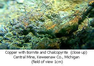
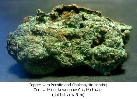
 around to see if there was an easier way to the top. When I made my way to the top Litha met me and said that I had taken the hard way. I metal detected at the top and went in the direction she came from. I found the best piece of the day sitting on the surface at the top.
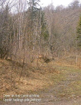
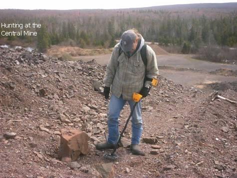
This looked like a great place to do some serious digging while we were up there, but this morning I wanted to show Litha the Central Mine ghost town. We went north and found the obvious intersection that takes you into Central. This wasnt our idea of a real ghost town. Several of the buildings looked occupied. There are two large tailings piles at Central, the upper pile being near the settlement. We saw a deer by the upper tailings pile and Litha just snapped this picture as it ran away.
We hiked to the lower tailings pile and tried some metal detecting. The actual fresh rock pile has been gone over time and again by metal detector clad rockhounds, and I didnt find much there this time. I did however find some goodies in the field above the pile.

When wed had enough on the rock pile we drove around some more in the ghost town and returned to camp. It was a cool, rainy night.